Blue Heron Trail
Overview
{this page is under construction as of March 2026}
Detailed Trail Description
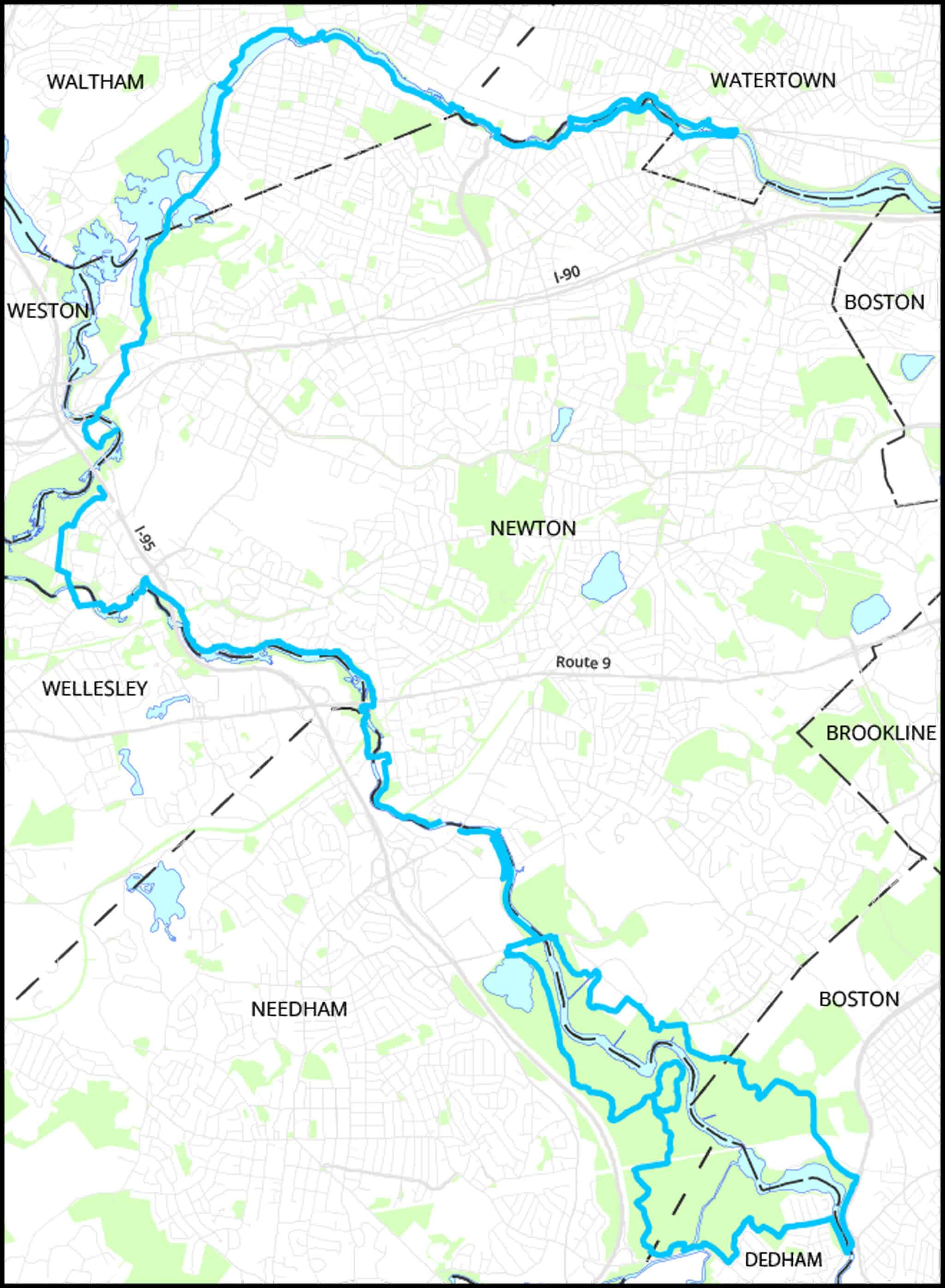
The BHT heads west from the Galen Street bridge in Watertown, with paved paths on both sides of the river. On the south side, the trail passes through Forte Park, with a playground and restrooms. On the north side, it passes the Dealtry swimming pool and several viewing platforms.
The first landmark in this area is the Watertown Dam, which may not exist within a few years. Proponents of removing the dam argue that removal would reduce flooding, enhance the passage of migratory fish, and make boating possible. Just upriver from Bridge Street are the remains of the Bemis Dam, which was built in 1778 to power adjacent mill buildings. Soon the BHT crosses the river on the Blue Heron Bridge, a 140-foot suspension bridge completed in 2005. The trail crosses the river again on Farwell Street. At Elm Street, the trail branches. One branch crosses Elm Street and follows a riverside path until it crosses the river on a footbridge leading to Landry Park on Moody Street. The other branch turns right and crosses the river on the Elm Street Bridge. where it turns right and makes a U-turn under the bridge toward
Landry Park. On the way, it passes the Charles River Museum of Industry & Innovation, in an 1814 mill building.
After crossing Moody Street, the BHT continues through Riverwalk Park to Prospect Street, where it turns left, crosses the river, then turns right next to the former Waltham Watch Company. It then passes DCR’s Woerd Avenue boat launch to Forest Grove and Auburndale
Playground (Site 2).
After reaching Commonwealth Avenue, city streets take the trail to the Boathouse Bridge (rebuilt in 2025) near the Leo J. Martin Golf Course (Site 6). After crossing the river on the Pony Truss Bridge, the trail crosses I-95 on two abandoned railroad bridges that are planned for restoration as the “Two Bridges Trail.” The BHT follows city streets to Concord Street and then passes over the Lower Falls Pedestrian Bridge. The trail soon reaches the Mary Hunnewell Fyffe Footbridge at Cordingly Dam. This bridge was built in 1983, replicating the design of a bridge from 1909. It was named after Fyffe, who fought for the preservation of open space along the Charles after parkland was destroyed for the construction of Route 128 in the 1950s.
Beyond the footbridge, the trail follows city streets to Quinobequin Road. The trail then follows a scenic path through the woods along the river. After passing under Route 9, the trail enters Hemlock Gorge (Site 17). The trail climbs a steep hill on the west side of the river and crosses the Sudbury Aqueduct (Site 27) at the end of the historic Echo Bridge.
South of the Gorge, the BHT follows city streets to Bobby Braceland Playground, where a short riverfront segment begins. The trail soon crosses the end of the Upper Falls Greenway (Site 18). Construction of stairs at this connection is planned for 2026; consult our website for details.
From the Needham Street Bridge, the trail follows the west side of the river across from Nahanton Park (Site 23) to Kendrick St. Here the trail branches. The west branch goes through Cutler Park (Site 25) and then follows city streets to its terminus at DCR’s Riverdale Park on Bridge Street in Dedham. The east branch passes through the Helen Heyn Riverway Conservation Area. (Heyn was a founding member of the Newton Conservators.) Next the BHT skirts the Wells Avenue Office Park and passes through DCR land to reach Boston’s Millennium Park (Site 26). From there, the route follows the busy VFW Parkway to Bridge Street, crosses the Charles, and ends at Riverdale Park.
Maps
Locator Map and Driving Directions
Detailed map
A detailed 18×24 map showing the routes of the Blue Heron Trail is included in the 2026 edition of the Conservators Trail Guide. Additional copies of the map area available for purchase. Follow this link to see the map on your computer.
Maps of trail segments
Printable maps of the entire trail, divided into seven segments, are under development. They will be posted on this page.
Individual sites along the Blue Heron Trail:
Auburndale Playground and Flowed Meadow
Mary Hunnewell Fyffe Footbridge
Trail Map
Click map for larger image •
Owner & Administrator Websites
Photo Gallery


First three photos shown here. Click a photo to view the complete slideshow or click here to browse the complete gallery.
Features
Biking: Good, Birding Hotspot, Blue Heron Trail, Boat Launch, Canoe & Kayak Rental, Conservation Area, Dogs On Leash, Generally Accessible Trail, Historic Site, Picnic Tables, Playground, River/Lake/Pond, Scenic View, Winter Sports