Brook Farm Historic Site and Millennium Park
Overview
This National Historic Landmark is a diverse mix of terraces and knolls covered by fields, forest, and a cemetery whose adjacent marsh and wetlands include a small brook on the south and the Charles River on the west. Once farmland, trails now lead through a mix of wetlands, meadows, fields, and woodland.
Size: 248 acres total: Brook Farm (148 ac) and Millennium Park (100 ac) Longest Walk: 2 miles Acquired: 1988
Charles River to Newton Centre
The Charles River in South Newton and Boston: Blue Heron Trail to Millennium Park
Maps
Locator Map and Driving Directions
Located in the West Roxbury neighborhood of Boston
Get here by MBTA: Route 52 Directions from Green Line
Other maps and aerial photos: Bing Maps bird’s-eye view
Connects to: Blue Heron Trail
Nearby: Cutler Park
Trail Map
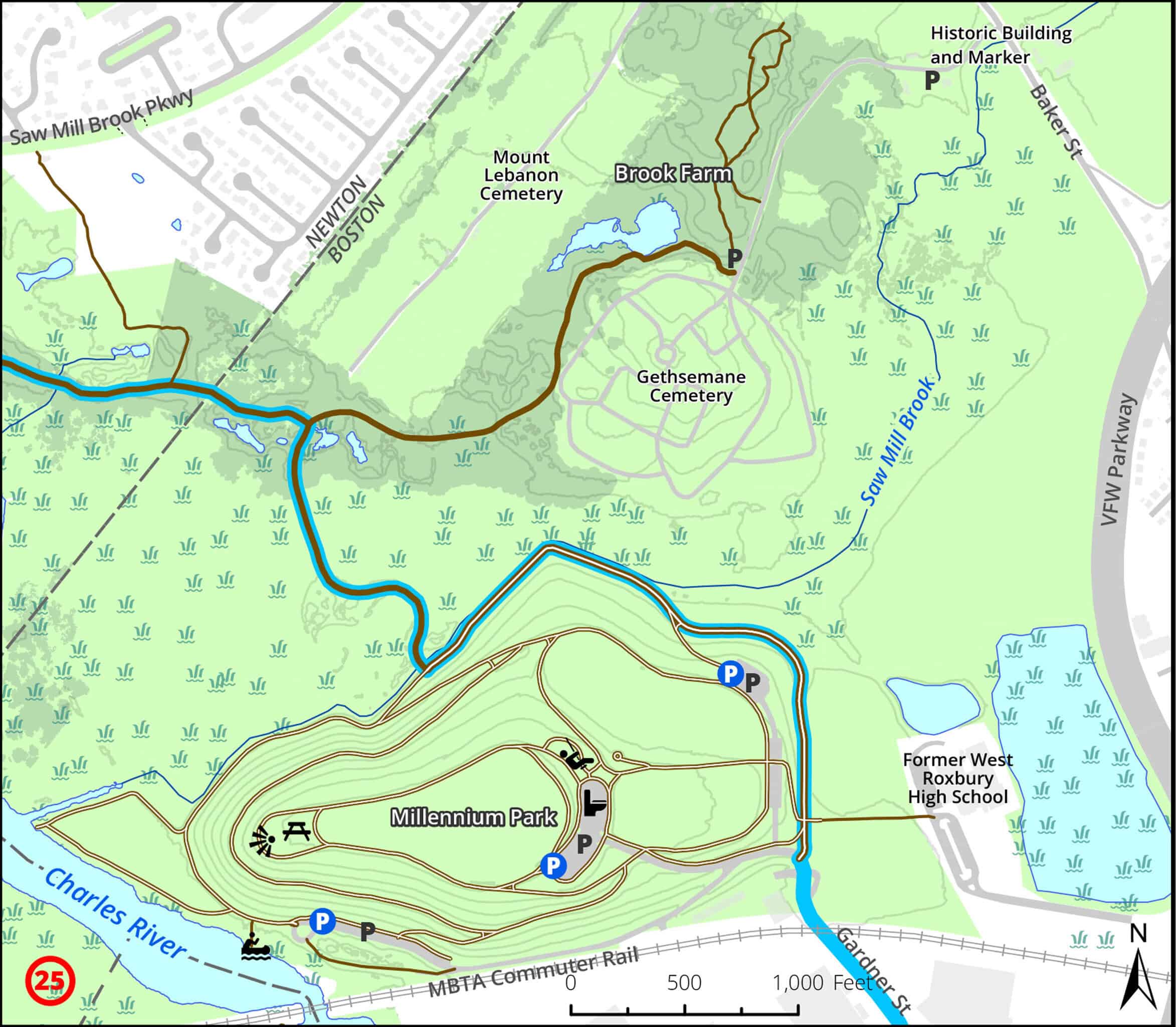
Click map for larger image •
Owner & Administrator Websites
Photo Gallery


First three photos shown here. Click a photo to view the complete slideshow or click here to browse the complete gallery.
History
This is the site of the 1840s Brook Farm experimental commune of Transcendentalists including Hawthorne, Dana, Greeley, Ripley, Margaret Fuller, and others. It was used briefly in the 1850s as a poor farm and in 1861 for training at Camp Andrew during the Civil War. A Lutheran orphanage occupied the farm from 1872 through 1943, with a treatment center on site from 1948 through 1974. Gethsemane Cemetery was established in 1873. Land was going to be developed into high-rises, before the state took over in 1988.
Features
Biking: Good, Birding Hotspot, Blue Heron Trail, Boat Launch, Dogs On Leash, Generally Accessible Trail, Historic Site, Other Long Route, Picnic Tables, Playground, River/Lake/Pond, Scenic View, Sports Fields, Toilet Facilities, Winter Sports
Additional Information
Newton Assessor’s Map ID: [not in Newton]
General Information:
DCR website and brochure for the park
The Gardens at Gethsemane cemetery is adjacent to Brook Farm.
The trail along the river is part of the Blue Heron Trail
Advocates & Caretakers:
In 2012, a nonprofit organization called New Brook Farm was created to advocate for improvements to the site.
In 2020, New Brook Farm received a $20,000 Community Preservation Act grant from the City of Boston to fund an archaeology dig and landscape improvements.
In 2023, the group proposed that DCR fund the creation of a “demonstration farm” on the site.
History:
The story of Brook Farm as reported on Mass Moments, from the Massachusetts Foundation for the Humanities. Nathaniel Hawthorne’s 1852 novel, The Blithedale Romance, is set in a utopian community and was written after he lived at Brook Farm. Brook Farm: The Dark Side of Utopia, a history of Brook Farm by Sterling Delano, was published in 2004. A Season in Utopia is an earlier book about Brook Farm. My Friends at Brook Farm by John Van Der Zee Sears is published online by Project Gutenberg.


A letter about the history of the land, and the Shaw family. Historic Newton highlights Brook Farm’s transcendentalist roots Newton Tab, July 5, 2017
Report a Problem
Report a Problem on DCR Land