Hemlock Gorge and Echo Bridge
Overview
A National Historic Landmark, the handsome stone bridge contains the Sudbury Aqueduct, with a pedestrian walk on top. Visitors standing under the arch can make a fine echo and view the deep river gorge, waterfall, and steep hemlock-covered banks. Spectacular views atop the bridge.
Size: 23 acres Longest Walk: 0.8 miles Acquired: 1895
Maps
Locator Map and Driving Directions
Located in Newton, Needham, and Wellesley
Other maps and aerial photos:
Connects to:
Trail Map
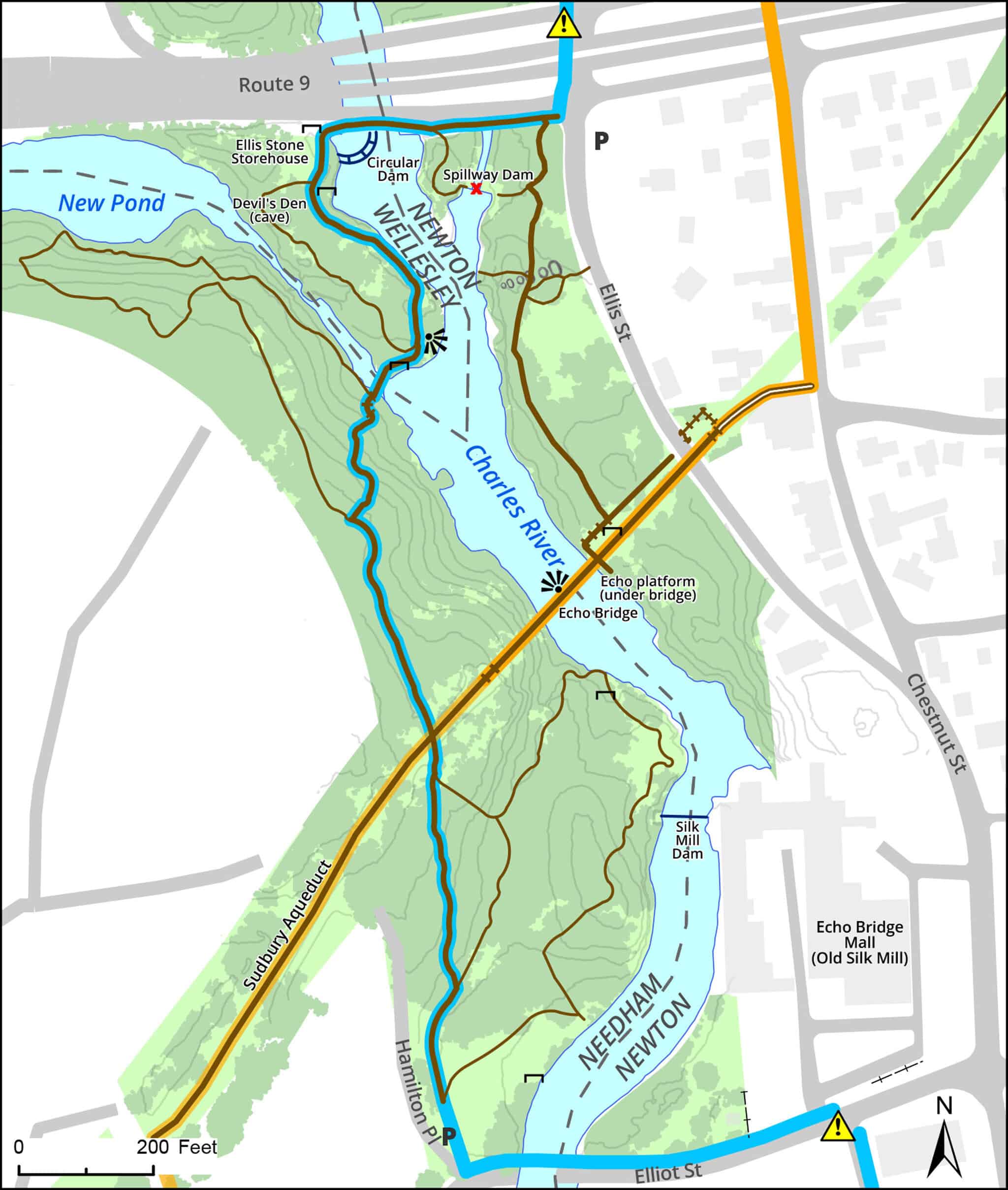
Click map for larger image •
Owner & Administrator Websites
Photo Gallery


First three photos shown here. Click a photo to view the complete slideshow or click here to browse the complete gallery.
History
1600s
English settlers knew the Ponkapoag Indians built a fish weir here to trap fish in the weir’s branches, catch fish from canoes, and smoke the fish on the river banks.
1700s
Grist mill, saw mill, fulling mill, snuff mills, and wire mill were built nearby.
1877
Echo Bridge built by Boston Water Works as the second largest masonry arch in the U. S.
1895
Acquired by the state for the Metropolitan Park System, one of its first purchases.
1984
MDC water system, including Echo Bridge, taken over by newly created Massachusetts Water Resources Authority (MWRA).
2006
Echo Bridge was briefly closed to pedestrians due to concern about safety of the railings. The bridge was soon reopened after temporary fencing was installed. The MWRA and city officials are seeking funding for permanent repairs. More info
2012
DCR rebuilds dike and spillway
Features
Aqueduct Trail, Blue Heron Trail, Dogs On Leash, Geologic Features, Historic Site, Other Long Route, River/Lake/Pond, Scenic View
Additional Information
Newton Assessor’s Map ID: 51001 0001 and other parcels in Newton and Needham
Advocates & Caretakers:
Walks and Park Information:
An AMC book, More Nature Walks in Eastern Massachusetts, describes an easy 1-mile walk in Hemlock Gorge
Another AMC book, WalkBoston, describes a 3-mile walk that includes Hemlock Gorge and Newton Upper Falls. See a map of this walk.
The park is described in the books, Walks in Wellesley and 111 Places in Boston That You Must Not Miss.
A Walking Tour of Hemlock Gorge, by Kenneth W. Newcomb
Acoustics of Echo Bridge, including a video of a saxophone performance on the listening platform
More about the Blue Heron Trail
More History:
1889 King’s Handbook of Newton
Historic Newton Upper Falls brochure
Kenneth W. Newcomb’s neighborhood history has a chapter that discusses Echo Bridge and Hemlock Gorge.
General:
Photos on Flickr … and more photos … and more … and still more
Preserving Echo Bridge (President’s message)
Echo Bridge Railing Restoration Project
“Echo Bridge” (a poem by Francis J. Ryan)
A book of poetry, Echoes in Hemlock Gorge, uses this park as a theme.
A new echo platform was opened in 2004 at the base of Echo Bridge.
Boston Globe article on Echo Bridge
Echo Bridge receives an inauspicious designation
![]()
Wikipedia entries:
A blogger visits the park with her dogs
Report a Problem
Report a Problem on DCR Land