Norumbega Park
Overview
Trails wind through a meadow, steep pine and hemlock covered riverbanks, and wooded knoll opening to a scenic view of the Charles River. There are tagged, honorary trees and shrubs in the meadow.
Size: 13 acres Longest Walk: 1 mile Acquired: 1976
Along the Charles River Path: Loop from Watertown Square to Auburndale
Maps
Locator Map and Driving Directions
Get here by MBTA: A 0.5 mile walk from Auburndale commuter rail station
Other maps and aerial photos: Bing Maps bird’s-eye view Newton Assessor
Connects to: Auburndale Park via a short walk on Commonwealth Avenue or Islington Road
Trail Map
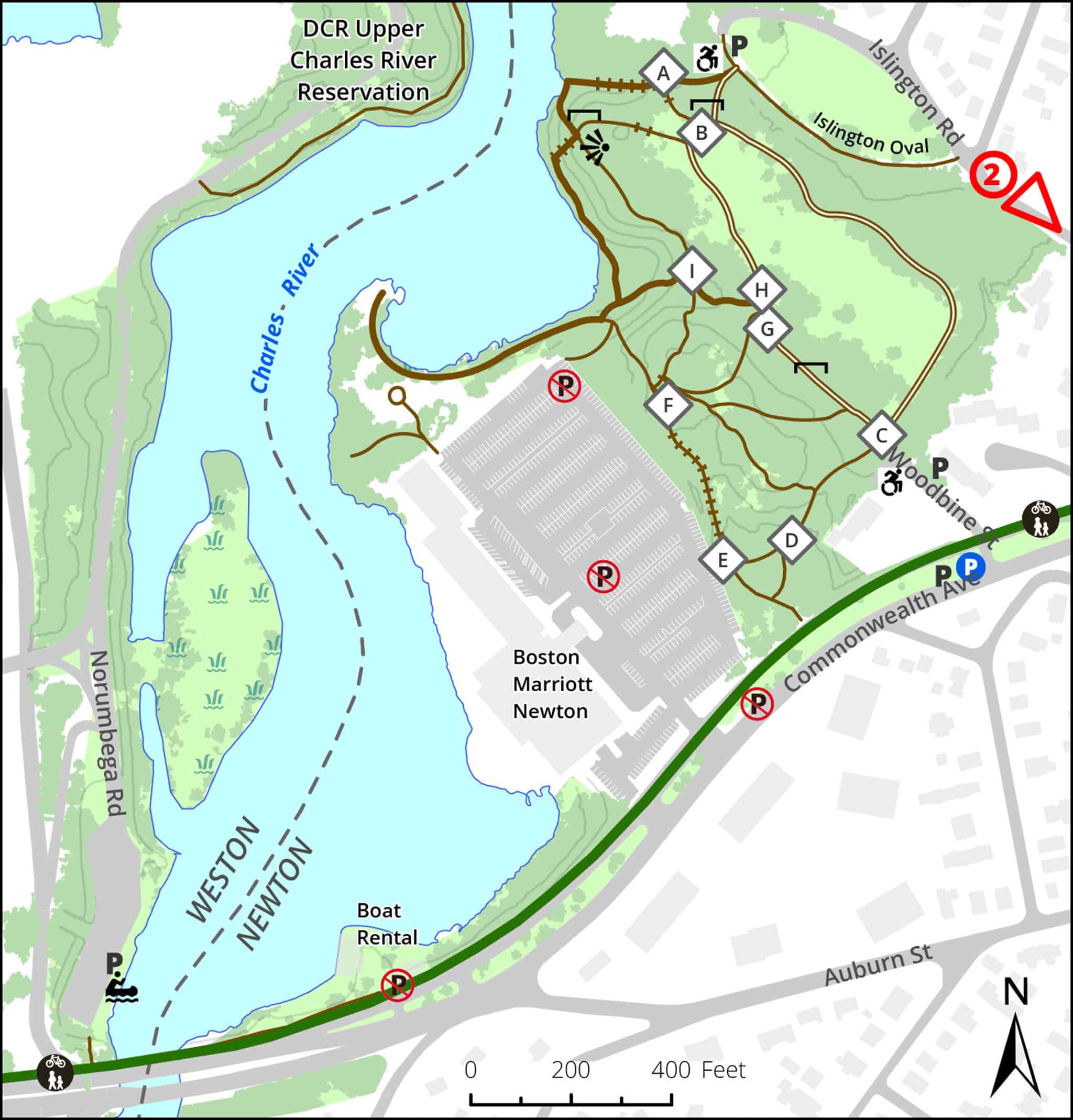
Click map for larger image •
Owner & Administrator Websites
Photo Gallery


First three photos shown here. Click a photo to view the complete slideshow or click here to browse the complete gallery.
History
1897
Part of Norumbega Park, a 27-acre, privately owned park situated at the end of the streetcar line from Boston. The park originally had a deer park, small zoo, popular canoeing facilities, amphitheater, and later the famous Totem Pole Ballroom.
1963
Norumbega Park closed.
1976
Using state funds, the City of Newton took by eminent domain the 13 acres of old Norumbega Park that remained after the 1969 construction of the Marriott Hotel on the western portion.
Features
Biking: Prohibited, Birding Hotspot, Boat Launch, Canoe & Kayak Rental, Conservation Area, Dogs On Leash, Generally Accessible Trail, Geologic Features, Historic Site, River/Lake/Pond, Scenic View, Winter Sports
Additional Information
Newton Assessor’s Map ID: 41023 0002
Canoeing and Kayaking
Paddle Boston (formerly Charles River Canoe and Kayak) offers canoe and kayak rentals at the historic boathouse on the Charles, near the park. A parking lot on the west side of the Charles provides parking for a boat launch as well as for the rental facility.
History
The NorumbegaPark.com website has historic information and photos. A Boston Globe article talks about the creator of the website, and about the park.
1889 King’s Handbook of Newton
Love Boats: The Delightfully Sinful History of Canoes
Books:
Norumbega Park and the Totem Pole Ballroom is an illustrated history of the amusement park.
An AMC book, Exploring the Hidden Charles, gives information about canoeing the Charles River.
The Charles River is an out-of-print book, available from online sellers. It also provides information about canoeing the Charles River and hiking near its banks. It includes USGS maps of the entire length of the Charles.
Photos:
Reviews:
![]()
Report a Problem
Report a Problem in a Newton Conservation Area