Webster Woods, Hammond Pond, and Houghton Garden
Overview
The largest conservation area in Newton is wooded, with noted rock outcroppings of Roxbury Puddingstone, brooks, ponds, wetlands, fields, and an historic woodland garden.
The middle of the woods was threatened by development following the purchase of 25 acres of land by Boston College in 2016. But in 2019 the City Council unanimously voted to take the 17 wooded acres of the Boston College land by eminent domain, assuring its permanent protection.
Activities to enjoy here are walking, jogging, nature study, geology study, birding, rock climbing, and cross-country skiing.
Gooch’s Caves – These are Roxbury Conglomerate fissure caves in the southwest section of the conservation area. Several marked trails pass by them.
Sandstone Ledges – These thick ledges alternate with Roxbury Conglomerate rock. They are sandstone formations that may have been river deposits. You can see the evidence of ripple marks, such as are made by water. Note the very long, almost vertical joints toward the westerly end of the ledges. The ledges are located west of Hammond Pond Parkway and north of the MBTA track, off the southbound lane of the Parkway. Enter the pathway about 600′ south of Beacon Street, where a loop trail circles around the ledges.
Deer Park – Mrs. Webster brought a couple of dozen deer into the area many years ago. No deer have lived in this mostly fenced area of six acres since 2010. In 2023, the Conservation Commission opened two gates in the fence and established a half-mile walking trail.
Hammond Woods and Pond – The trails and cliffs attract hikers and rock climbers. The pond, as a “great pond” (any pond larger that 10 acres) is state-owned, operated by the DCR. Its average depth is just four feet. Access is from the gravel beach on the west side of the pond, near the parking lot of The Street at Chestnut Hill shopping center. The pond and its adjoining marshes and woodlands provide valuable habitats for a diversity of wildlife, aquatic species, and native plants.
Houghton Garden – This wild garden is listed on the National Register of Historic Places. Its gracious paths, overhung by azalea and rhododendron, wind around a stream and lagoon-like pond. Water features were designed by Warren Manning, who formerly worked for the Olmsted studio.
Size: 230 acres Longest Walk: 2.0 miles Acquired: 1916-2019
Charles River to Newton Centre
Newton Centre to the Malls
Waban to Chestnut Hill
Webster Woods/Hammond Pond Trails
Maps
Locator Map and Driving Directions
Get here by MBTA:
a 0.5 mile walk from Newton Centre Station, or a 0.5 mile walk from Chestnut Hill Station
Other maps and aerial photos:
Trail Map
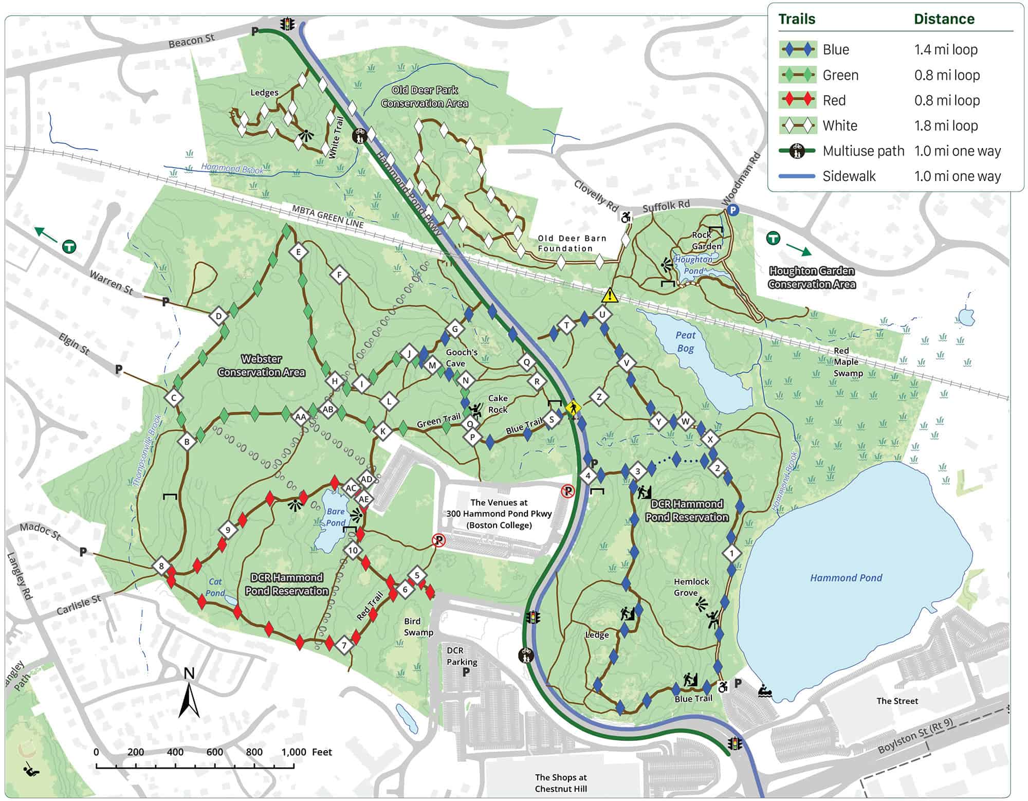
Click map for larger image •
Owner & Administrator Websites
Webster Conservation Area - Conservation Commission
Photo Gallery


First three photos shown here. Click a photo to view the complete slideshow or click here to browse the complete gallery.
History
1650
Thomas Hammond began farming the eastern section.
1852
A railroad line, now the MBTA, was built. The culvert from the 1850 Hammond Brook Canal went underneath the tracks.
1896
Edwin Webster bought the land and moved the Kingsbury house to 137 Suffolk Road. The Websters lived at 307 Hammond Street.
1916
The Commonwealth purchased land adjacent to Hammond Pond from John Lowell. Edwin Webster gave about 100 acres of the southern half to the Commonwealth. Read a history of the land written from Webster’s perspective.
1935
Webster donated a seven acre playground at the end of Warren Street to the city.
1954
25 acres were sold by the state to Congregation Mishkan Tefila, after an unsuccessful lawsuit by the City of Newton that attempted to block the sale.
1968
The City of Newton used its power of eminent domain to purchase 38 acres of land in Webster Woods from the Webster estate.
1972
City bought Webster Vale. This later became the Charles Cohen Conservation Area.
2016
Congregation Mishkan Tefila sold 25 acres of Webster Woods to Boston College.
2018
Newton Mayor Ruthanne Fuller announced plans to work to protect Webster Woods.
2019
Boston College built a road salt storage facility on the rear parking lot of its part of the woods. Mayor Fuller proposed using the city’s power of eminent domain to buy the 17 undeveloped acres of the BC land. Newton City Council unanimously approves the taking of 17 acres of Webster Woods.
2023
The former Deer Park north of the MBTA tracks was opened to public use after the creation of a loop trail.
Features
Biking: Good, Biking: Prohibited, Birding Hotspot, Boat Launch, Conservation Area, Dogs On Leash, Farm or Garden, Generally Accessible Trail, Geologic Features, Historic Site, MBTA Green Line, Other Long Route, River/Lake/Pond, Rock Climbing, Scenic View, Vernal Pool, Winter Sports
Additional Information
Newton Assessor’s Map ID: 65008 0002 and many other parcels
History and Description:
Webster Woods: A Natural Place of Memories and Discoveries, by Richard B. Primack, Professor of Biology at Boston University
Taking Care of Hammond Pond, by Jennifer Steel, Senior Environmental Planner for the City of Newton
Exploring in and around Boston on Bike and Foot, describes a 2-mile walk in Webster Conservation Area.
Hammond Pond Woods in King’s Handbook of Newton (1889)
“So broad and sequestered and unfrequented is this lovely forest that no sounds of prosaic human life invade its cloisters, and nothing disturbs the saunterer’s reflections but the low songs of the birds, or the scampering of an occasional gray squirrel over the dry leaves.”
Wikipedia 1970s map of Hammond Woods
![]()
Rock climbing info:
Recent Developments:
2003 Hammond Pond project begins
2010 Hammond Pond “Access Enhancements” Proposal
Photographs:
Photos on Flickr … and more … and more … and still more
Report a Problem
Report a Problem in a Newton Conservation Area